ファイル:Closeup of the Ice Island from Petermann Glacier - Flickr - NASA Goddard Photo and Video.jpg
元のファイル (2,979 × 1,986 ピクセル、ファイルサイズ: 2.74メガバイト、MIME タイプ: image/jpeg)
概要
| 解説 |
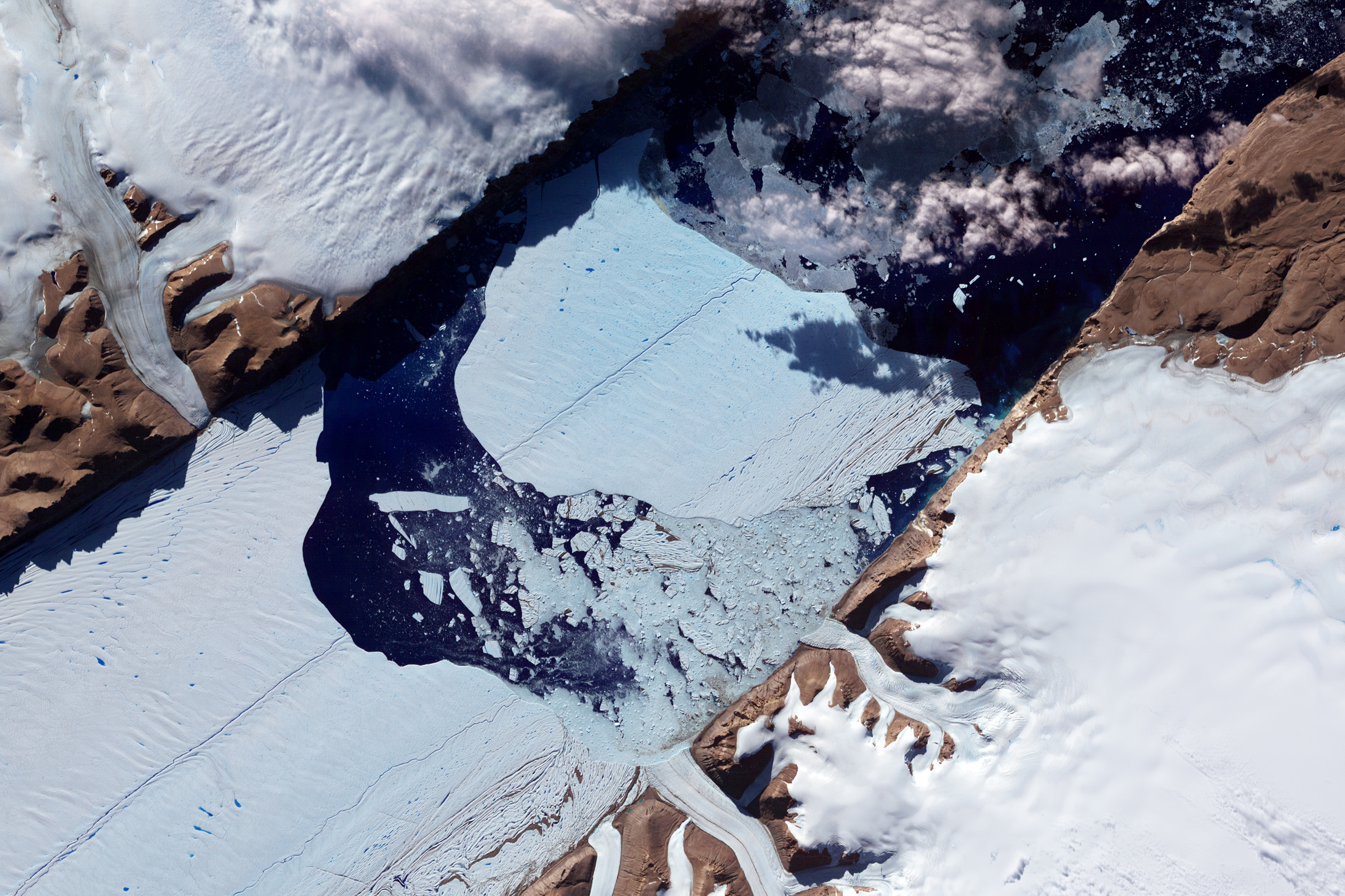
NASA image acquired July 21, 2012 In July 2012, a massive ice island broke free of the Petermann Glacier in northwestern Greenland. On July 16, the giant iceberg could be seen drifting down the fjord, away from the floating ice tongue from which it calved. On July 21, 2012, the Advanced Spaceborne Thermal Emission and Reflection Radiometer (ASTER) on NASA’s Terra satellite captured this image of the iceberg’s continuing journey. This image has been rotated and north is toward the right. ASTER combines infrared, red, and green wavelengths of light to make false-color images that help to distinguish between water and land. Water is blue, ice and snow vary in color from pale blue to white, and land areas appear brick red and brown. Clouds in the scene cast dark shadows onto the iceberg surface. Similar surface cracks appear on both the Petermann Glacier and the newly formed ice island. Nearly two years ago in July 2010, another large iceberg calved from the Petermann Glacier. That iceberg was estimated at roughly 97 square miles (251 square kilometers). The 2012 iceberg is estimated to be about half as big. This latest calving occurred farther upstream on the Petermann, but nevertheless occurred along a rift that appeared in satellite imagery in 2001. Ted Scambos of the National Snow and Ice Data Center observed melt ponds on the iceberg surface, but stated that the Petermann calving was likely associated with ocean currents rather than surface melt. NASA Earth Observatory image by Jesse Allen and Robert Simmon, using data from NASA/GSFC/METI/ERSDAC/JAROS, and U.S./Japan ASTER Science Team. Caption by Michon Scott. Instrument: Terra - ASTER Credit: NASA Earth Observatory NASA Goddard Space Flight Center enables NASA’s mission through four scientific endeavors: Earth Science, Heliophysics, Solar System Exploration, and Astrophysics. Goddard plays a leading role in NASA’s accomplishments by contributing compelling scientific knowledge to advance the Agency’s mission. Follow us on Twitter Like us on Facebook Find us on Instagram |
| 日付 | |
| 原典 | Closeup of the Ice Island from Petermann Glacier |
| 作者 | NASA Goddard Space Flight Center from Greenbelt, MD, USA |
ライセンス
- あなたは以下の条件に従う場合に限り、自由に
- 共有 – 本作品を複製、頒布、展示、実演できます。
- 再構成 – 二次的著作物を作成できます。
- あなたの従うべき条件は以下の通りです。
- 表示 – あなたは適切なクレジットを表示し、ライセンスへのリンクを提供し、変更があったらその旨を示さなければなりません。これらは合理的であればどのような方法で行っても構いませんが、許諾者があなたやあなたの利用行為を支持していると示唆するような方法は除きます。
| この画像は当初、NASA Goddard Photo and Video によって Flickr の https://www.flickr.com/photos/24662369@N07/7638834528 に投稿されたものです。2012-08-17、FlickreviewR ボットによってレビューされ、cc-by-2.0 のライセンスで提供されていることが確認されました。 |
| このファイルはアメリカ航空宇宙局(NASA)によって作成されたものです。NASAの著作権の方針では、特記事項が無い場合、NASAの資料はパブリックドメインとなります。 (詳しくはTemplate:PD-USGov、NASAの著作権の方針について(英語)又はジェット推進研究所(JPL)の画像使用に関するガイドライン(英語)をご覧ください。) |
||
 |
注意事項:
|
ファイルの履歴
過去の版のファイルを表示するには、その版の日時をクリックしてください。
| 日付と時刻 | サムネイル | 寸法 | 利用者 | コメント | |
|---|---|---|---|---|---|
| 現在の版 | 2012年8月17日 (金) 20:13 | | 2,979 × 1,986 (2.74メガバイト) | Werieth | == {{int:filedesc}} == {{Information |Description=NASA image acquired July 21, 2012 In July 2012, a massive ice island broke free of the Petermann Glacier in northwestern Greenland. On July 16, the giant iceberg could be seen drifting down the fjord, ... |
ファイルの使用状況
以下のページがこのファイルを使用しています:
グローバルなファイル使用状況
以下に挙げる他のウィキがこの画像を使っています:
- bn.wikivoyage.org での使用状況
- en.wikivoyage.org での使用状況